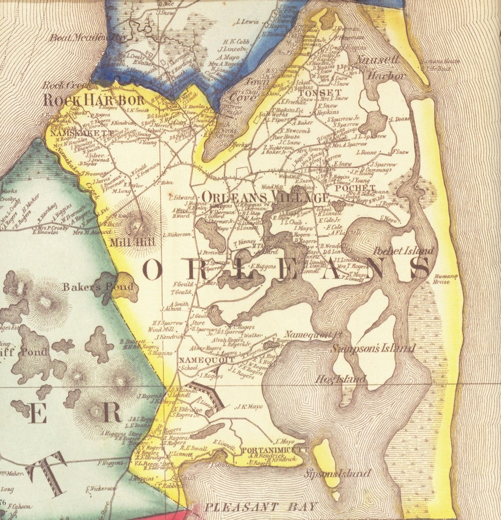
A picture of 1858 Orleans
- Jan 13, 2018
- 3 min read
A special article by our winter break intern, originally published in the Cape Cod Chronicle, January 2018
When combing through artifacts as part of our packing for renovation work, volunteers at the Orleans Historical Society uncovered a large map of Cape Cod and the Islands dating back to 1858. The map is very detailed, listing off everything from geographic features and street names to the homes and businesses of prominent families. The 5 foot by 5 foot map was created by renowned cartographer Henry F Walling in 1858, who worked for the Commonwealth of Massachusetts as the official state topographer. He went on to be contracted by the US Geological Society to draw up maps of more than one hundred and fifty maps of towns and counties from across the United States. This 1858 map details many of the more populated communities at the time – such as Barnstable, Chatham, Provincetown, and Nantucket – and includes their business listings and statistics, giving a glimpse back into these bustling towns. When specifically looking into Orleans, notable features include the homes of sea captains, the humane “life-saving” houses, and the businesses that drove the town more than 150 years ago.
Walling’s map zooms-in on the “Orleans Village” and “Rock Harbor Village” to detail the homes of local sea captains, such as the Crosbys, and prominent families that are clearly seen today in contemporary Orleans, such as the Nickersons and the Snows. It also details the numerous salt works that dotted the marshes on the Eastham and Orleans bayside, and the businesses ranging from shoe and clothing stores, to tin shops and barbershops. In addition, the four identical-looking schoolhouses of Orleans – one in the North, South, East, and West – are found on Walling’s map. However, not all of the buildings are marked on Walling’s map that were present in Orleans in 1858. This is because the map was subscription based, meaning that people and businesses had to pay to be placed on the map.

Looking at Orleans’ outer beach, there are two locations marked as “humane houses”; one is on Nauset Beach near Pochet Island, and the other is near end of Coast Guard Beach. Humane Houses were small shacks built along the coastline in isolated areas to serve as a temporary shelter for sailors or passengers stranded from shipwrecks. The construction of these houses were driven by the need for shelter and supplies for survivors of shipwrecks once they landed on shore, because sailors often died from harsh conditions before rescuers arrived. Back in 1786, The Humane Society was established in Massachusetts to help in the effort to save shipwrecked sailors. They began constructing “huts” built along isolated beaches filled with supplies, which provided protection while waiting for townspeople to help. By 1806, eighteen humane houses had been built along the Massachusetts coast. The Humane Society then began constructing “lifeboats” around 1807, so that people could cut through the surf at the immediate shoreline in order to rescue those further out. By the time the Humane Society was absorbed into the US Life-Saving Service in the late 1800s, seventy-eight lifeboats and ninety-two huts were in operation along the Massachusetts coast.
The detail this map allows for many directions to be taken in research and in discovering old stories about Orleans and about almost every town on the Cape and Islands. There is a lot of information on Walling’s map, which makes it incredibly interesting and unique to find out the history of each town using only a map. Once renovations to the OHS Meetinghouse are completed, this map will be put on display in our spring exhibit for viewing.


